 |
| Sentry Team preparing for the dive. |
Sentry starts a dive with a pre-programmed series of distance (range) and direction (bearing) instructions that it will follow and will take it far from the ship (about 10 km or 6 miles) during which Sentry will record very precise (within 10 cm elevation) multibeam sonar bathymetric data with a horizontal resolution of ~1 meter. Every 6 hours or so Sentry must come back within acoustic range of the ship to text message with the Sentry team through a transducer (acoustic modem) on the bottom of the ship and communicate things like how much battery power remains and how Sentry’s other systems are working. The Sentry team can also send Sentry a text message to tell it to offset its track slightly to compensate for any navigational drift that has occurred during its travels alone in the ocean.
 |
| Image of an actual live Sentry track screen. Red lines have been confirmed to have run. Green lines are the rest of the set track. |
The final result of the Sentry missions on our research cruise will be high-resolution bathymetric maps that will be used to measure any changes in elevation of the sea floor by comparing this summer’s measurements with those from previous years. These changes in the sea floor are primarily due to subsurface magma movement inside Axial volcano.
Chief Scientist Bill Chadwick discussing Sentry navigation:
Most people who use Sentry to survey in a “mow the lawn” pattern to create bathymetric maps of previously unmapped areas. In contrast, on this cruise we want to measure deformation of the volcano by repeating previously mapped survey lines to look for changes in seafloor elevation. We also want to do these repeat surveys over a large area to reveal the spatial extent of the deformation. Most people map assuming the sea floor topography will never change (which is true in most areas), but here at an active volcano, the seafloor moves up and down as magma moves in and out of Axial Seamount. Comparison of these surveys from year to year allows us to measure deformation at the volcano as it inflates and deflates over time. This process of comparing high resolution AUV multibeam data in order to determine volcanic deformation on the sea floor was developed by the scientists on our cruise in collaboration with scientists at MBARI (Monterey Bay Aquarium Research Institute).
Before developing this method with the AUV data, pressure measurements (for inflation and deflation) were only at specific points but Sentry gives us information over a much greater area. On the other hand, these AUV measurement comparisons are not as precise as our pressure measurements (more about those in a later post), so it is good to have both kinds of data when developing our models for the volcanic activity at Axial.
Sentry Navigation
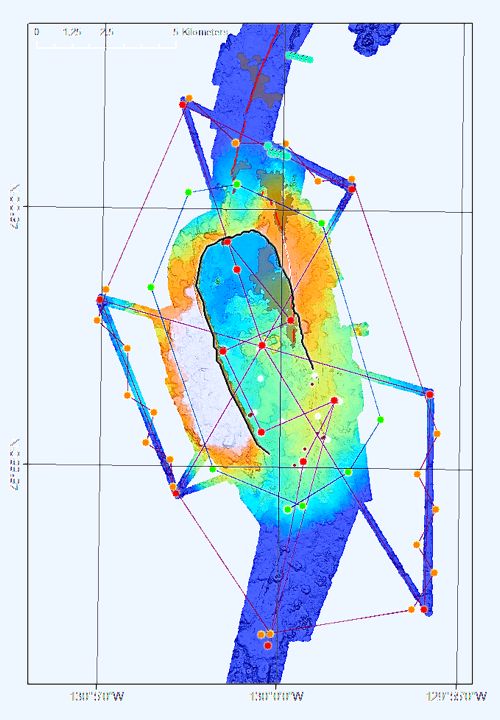 |
| Map of Axial showing the waypoints for measuring deformation. |
In the end we’ll be able to determine how much the seafloor has risen since the last AUV survey a year ago and what that can tell us about how magma is supplied and stored inside the volcano. We know that Axial is already building to its next eruption and this information will help us forecast when that is likely to occur.